Categorization of Intervisibility Lines
Intro | Definition
| Components | Labeling | Finding
| Final Note
"Why
should I care about these IVL things?!"
Hey!
I heard that! Here's why!
When
maneuvering armored vehicles over open terrain against an enemy that could shoot
back, soldiers quickly found out that they could exploit the subtle folds in the
ground to gain a decisive advantage. Whoever got to the position
first could either use it as a defilade and shoot the advancing and exposed
enemy, or they could stop short in a hasty reverse-slope defense and spring an
ambush. Because this was a subtle fold in the ground it wasn't obvious on
the map. Before long, soldiers were recording these locations for
future use, giving birth to the first "IV Line Overlay".
The name seems to have come out of the National Training Center at Ft Irwin,
California in around 1987.
Although commonly associated with the vast open expanses of desert battlefields,
the concept is often useful in other environments and circumstances.
Introduction
Ever
ask a Topographic Engineer to help you find an Intervisibility Line?
No? If you are reading this
in a Division, take a minute and call your Topo Engineer.
Ask him or her for their " Intervisibility Line Overlay" for
your Post or your unit's favorite training area.
Go ahead, I'll stop writing for a minute and wait while you make the
call....
What
happened?
Did
they explode over the phone? Did
you get a lecture about how Intervisibility Lines don't exist?
Were
you called Ugly Names?!
To
hear soldiers talk you would think that Intervisibility Lines are tangible,
physical object behind which to hide.
To hear a commander shout "Hey S2 - gimme some EYE VEE LINE
locations we can use!" you might think that they were a SIXTH type of
terrain feature discovered since your last map reading class.
Intervisibility
Lines (IVLs) are not terrain features, but an effect of terrain on
observation. While
Terrain Features are absolute and can be readily distinguished independent of
the observer’s location,
IVLs are relative. Topographic engineers dislike the concept of IVLs
because of this relative nature. Combat Arms soldiers insist on using them
because they describe a very real phenomenon, and are extremely useful in
describing terrain from the Observation & Fields of Fire standpoint.
The
problem is that not only have IVLs not been adequately defined, but they are not
all the same due to the great variety of terrain and their relative nature.
This article therefore aspires to achieve three worthy goals:
1)
You got to meet your Topo Engineer, perhaps for the first time.
(You DID make that call, didn't you?!)
2)
It presents a definition of IVLs that might even satisfy your new topo friend.
3)
It presents some methods for categorizing IVLs that will be useful for you in
describing them to commanders, staffs, and other soldiers.
Defining the IVL
-
Intervisibility is the ability to to see from
one object or station to another. (FM 5-33, Terrain Analysis, p 7-1)
-
Line of Site (LOS) is an unobstructed view
from point A to point B. (FM 5-33, Terrain Analysis, p 7-1)
-
Observation (as in the "O" in OCOKA)
is the set of points which have LOS from one specified location. In other
words, what you can see.
-
Field of Fire (the other half of
"O" in OCOKA) is the set of points which have LOS from one
specified location out to the maximum effective range of a specified weapon.
In other words, what you can shoot. The rest of the points are called "deadspace".
Intervisibility is
the general concept. Line of Site is the concept of
Intervisibility applied to two points. Observation
is the concept of LOS applied to One Point in relation to All Other points. Field
of Fire is the concept of Observation limited to a specific
linear distance.
Definition
of InterVisibility Line
A relative,
localized, pattern
of limitations on observation, caused by (often
subtle) variations in terrain elevation.
Relative:
Regardless of perspective or location, a hill is defined by concentric contour
lines and remains a hill. This hill is Pikes Peak... that
hill is a pitcher's mound. An IVL only exists in a specific frame of reference
in relation to an Observer and the Observed. Move the observer from a fighting
position to a tank, and the IVL changes. Put him in a helicopter and it might
disappear. Change the Observed from dismounted Infantry to tanks and the IVL
likely changes. This characteristic of IVLs makes the Topo engineer wince.
Localized: Given a fixed frame of reference, an IVL can be
assigned to a specific geographical place. This characteristic keeps the concept
of IVLs alive, and results in the infamous "NTC IVL Overlays" that
Infantry/Armor commanders continuously refine.
Pattern: Given a
fixed frame of reference, and a defined location, the IVL restricts observation
in certain, predictable ways. This is generally known, but the patterns have not
been described beyond the term "Line". Not all patterns are linear.
(Often subtle) Variations:
The Observers/Observed are usually 1-2 meters in height. Map contours are
generally 10 or 20 meters. There are many terrain variations that are less than
10-20 meters in height, and are not obvious unless they happen to pass through a
contour interval. When these variations become large in relation to the
observer/observed, they may block observation and constitute an IVL. The only
upper limit in defining IVLs is common sense and usefulness. Yes, the Huachuca
Mountains lying south of Ft Huachuca constitute an IVL for those looking from
the Intelligence Center south into Mexico; but why waste time marking the
obvious? It is that subtle fold in the ground, which will hide the tank company,
that will stop your attack cold.
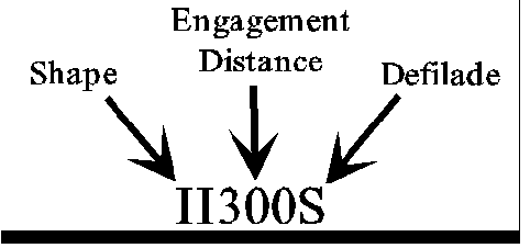
Components
of an IVL
Shape | Engagement
Distance | Defilade Quality
Shape
IVLs tend to fall into one of the four shapes
illustrated below. Although contour lines are used to illustrate the basic
shapes, keep in mind that the IVL is not a terrain
feature.
|
|
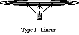
Type I
- Blocks LOS uniformly along a line to the front. This is what is
commonly visualized by "Intervisibility Line". Although
portrayed as a long hilltop, in reality this is usually a subtle fold in
the ground. Imagine moving your eye across a flat table - the table's
edge is a Type I IVL. |
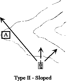 |
Type
II - Blocks LOS more to one side than the
other. In the diagram, there is no LOS restriction on the left-most
arrow. In fact, to an observer at "A", there is no LOS
restriction at all! Imagine walking around the side of a hill while
maintaining the same elevation. As you walk, the edge of the hill to
your front becomes a horizon. A friend standing at the bottom can see
both you and what lies ahead of you over your localized horizon. |
|
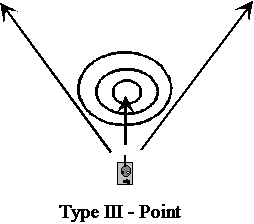
Type
III - Blocks LOS directly ahead, but
allows LOS to either side. The drawing depicts a tank approaching a
small hill. If the tank continues to steer directly toward the hilltop,
the Type III Point IVL will become a Type I Linear IVL. If the tank gets
very close and veers around either side, the Point IVL becomes a Type II
Sloped IVL. Strictly defining the transition point between the types of
IVLs is not important... ensuring the tank crew understands the effects
the terrain will have on their (and the enemy's!) observation, fields of
fire, cover and concealment is extremely important! |
|
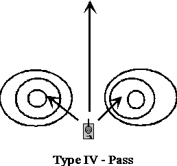
Type
IV - Blocks LOS to the sides, but not to
the front. |
Note that the observer's size and location determine whether
there is an LOS obstruction as well as its type. A pitcher's mound is a Type III
IVL to a turtle at 10 meters, and may become a Type II if he chooses to skirt
the edge or a Type I as he crawls over the top. The mound presents no LOS
obstruction to people.
Engagement
Distance
This is the distance at which you can expect to
be able to engage the enemy. This is a relative value based on the forced
involved. If you are in an armored unit fighting an armored unit, and both are
in the open, the 2 meter height is acceptable. If armor is attacking a dug-in
defense, then the dug-in side must be calculated at 1 meter. Dug-in dismounts
are less than 1 meter height.
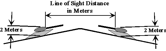
The distance in meters that a 2 meter high object can
see another 2 meter high object across the IVL. In other words, how
close will the vehicles get before they can shoot each other? |
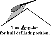
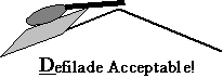
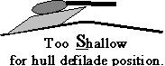
Defilade
Quality
Addresses the suitability of the IVL to provide
a hull defilade position to an armored vehicle. Obviously, this is relative to
the type of vehicle or force that might use the IVL for this purpose.
Labeling
IVLs
Finding
IVLs
There are four major ways of locating
IVLs, in order of preference...
1. The best
way is to ask soldiers who have fought or trained on the terrain.
2. Walk over the terrain yourself. Ensure you
fully understand the nature of the equipment you and the enemy will use. What
is the height of the M1, M2, T80, BMP? The height of the gunsight? Works best
if you take a friend, powerful binoculars, and lots of time.
3. Find IVL overlays of the area. They exist in
abundance for NTC, but maybe not for where You will have to fight.
Once you locate them, go back to techniques #1 and #2
in order to verify they exist where the overlay says they exist, and also to
verify their characteristics.
4. Use topographic software like MicroDEM. Caution!
-
The DMA mapping data used by MicroDEM (and
other such programs) is only accurate to the 10 or 20 meter contour
interval... even though some programs will let you set the interval much
lower.
-
These programs use a finite number of
points and then calculate where to contour lines should go through
interpolation.
-
They do not account for the effects of
vegetation on LOS.
Aside from that, they are the next best thing
to being there. These programs do not have a "Find IVL" function, so
use the following technique.
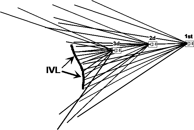
a. Determine the area of interest.
b. Assume the role of the moving force. If
both sides will be moving, assume the role of your own force.
c. Take a series of LOS snapshots. In
MicroDEM, select Overlay |
Weapons Fan from the pull-down menu. Between
each snapshot, move 500 to 1000 meters in the direction of attack. The
program will draw a series of lines radiating from your location... the
lines indicate the terrain you can see. The lines break for deadspace.
d. After two or three snapshots, you will
notice a few areas of deadspace that the snapshots had in common. The edge
of the deadspace nearest the attacking unit is an IVL.
e. You must then study the pattern of LOS
rays to determine the Shape. The length of the LOS rays
as moving force moves through the IVL provides the expected Engagement
Distance. You must walk the ground to get Defilade
information.
Final
Note
Quantitative vs Qualitative criteria.
The qualitative approach described above, using
commonly understood or consistent definitions, will be sufficient for most
tactical applications. It will certainly suffice in the early stages of
verifying the usefulness and value of this system of categorization.
It was tempting to apply computer-aided
geometry in order to add mathematical precision to IVL categorization. As far as
we know, no attempt has been made to do so. You must therefore use your own best
judgment to determine which of the above categories best describes an
encountered IVL, then use the categories as a communication and analysis tool in
developing tactical operations. Never forget to supplement map reconnaissance
with ground reconnaissance. As stated before, a 20-meter contour interval leaves
out a lot of detail, and the DMA data set referenced by MicroDEM, TerraBase, and
other mapping programs is little better. Use no more precision than is required
to get the job done. It is far more important to have a commonly understood
labeling system to describe IVLs, than it is to attempt to add a facade of false
precision.
Eventually someone may develop an automated
system to locate and categorize IVLs from DMA terrain data.
© Copyright The S2 Company, 2002, All Rights
Reserved. Unlimited personal use and free distribution allowed.

Intro | Definition
| Components | Labeling | Finding
| Final Note